WELCOME
Agroxchange Technology Services Limited
Agroxchange Technology Services Limited is a Nigerian-based digital technology company, that uses satellite data to offer crop health insight as early warning for farmers to take quick action against threats, throughout the crop growth stage, from planting to the harvest stage to optimise crop yield. Agroxchange Technology Services Limited operates a smart farming advisory and technical centre based in Akure, Ondo State, South West Nigeria.
Our services enable
- Farmers that have land but are not yet producing to understand the viability of the land in terms of crop suitability and soil capacity,
- Farmers that are already producing to monitor the health of their crops and receive notifications when issues arise,
- Financial institutions and lenders to monitor loan disbursements and ensure loan recovery,
- Off-takers and aggregators to manage their spending on inputs and increase their profit margin with evidence of service that include web-based interactive map of the farm boundary showing all information about the farm including the farm health level and,
- Provide digital data access to agricultural investors to facilitate informed decision-making on crop production.
Agroxchange Technology Services Limited understands the constraints farmers face in rural settings that include low disposable income, low access to power and low access to data networks and as such we provide only localised data and information advisory to enable them to make informed decisions without needing to commit to additional financial responsibilities such as purchasing smart devices or laptops.
Since its founding in 2018, Agroxchange Technology Services Limited has been at the forefront of leveraging cutting-edge technologies and data, simplifying complex precision agriculture and weather information to increase the profitability and efficiency of smallholder farmers. Millions of smallholder farmers in Nigeria make uninformed farming decisions and poor usage of inputs e.g. fertilizers and seeds, resulting in over $10 billion in annual losses across the entire agricultural value chain. Agroxchange Technology Services Limited mitigates these risks and improves livelihood for farmers.
Ethical application of digital technology for agriculture to achieve measurable impact in terms of livelihood improvement for farmers and youth including women.
- Build resilience in food security through the application of digital technologies for improvement in crop production
- Accelerate the uptake of climate smart technologies for agriculture among African farmers.
- Increase farmer compliance with Good Agronomy Practices using technology and digital data advisory.
- Become the largest ware house of digital agricultural productivity data in Sub-Saharan Africa.
Initiation Stage
- Onboard would be farmer and exsiting farmer through our user needs assessment forms
- Identify and sign MOU with offtaker
Pre-farming stage
- Baseline mapping and data collection and primary production benchmarking
- Manage effective distribution and application of inputs
- Build capacity of farmers on Good Agronomy practices
- Create awareness and buying of farmers on harvest optimization
Farming Stage
- Record and report each growth stage of crop.
- Monitor production status from planting to harvesting using field teams and satellite crop monitoring platform to optimise harvest.
- Monitor compliance of farmers with Good Agronomy Practices with respect to harvest optmisation
Harvest Stage
- Work with aggregator to harvest and aggregate harvest
- Supply harvest to offtaker
Verification of inputs
Confirmation of harvest
Verification traceability of harvest
Insurance cover against crop loss
Death
Disability
Agricultural Business Risk Such As Outbreak Of Pest, And Disease, Flood, Fire, Animal Encroachment, Lightning
Periodic yield monitoring using Artificial Intelligence
We answer the following questions and offer these services
We answer the following questions for you.
- What crop can grow optimally on the land for me to make profit from my farm?
- What is the soil type and nutrient composition for the area?
- Are there water sources in the area to support irrigation during dry season farming?
- How much arable land is available on my land?
- Will the land flood during wet season?
- Can I have the GPS map of the land online to see its location relative to other features?
Onboarding form
Click to let us help you.
We answer the following questions for you.
- What parts of my farm are performing optimally and what parts are not?
- How do I receive automatic notifications on my email and SMS if issues arise on my farm?
- Is there a way I can see if my crops are getting enough water and there are no problems affecting my crops?
- Can you spray my farm using drones?
Onboarding form
Click to let us help you.
We provide the following information for Lenders, Crop protection Company and offtakers
Product Features
- Lender: this farmer is due to plan in three weeks and expressed an interest in hybrid seeds last season. Satellite images show consistent, high yields for three years.
- Crop protection company: this farmer is four weeks into a rice crop, and the crop is inundated with Brown Plant Hopper.
- Offtaker: this farmer is one week away from harvest, with an estimated 6 tonnes of white maize.
We answer the following questions for you.
- Can you manage my crop farm from end to end?
- Can you optimize my farm to make profit?
- Can you apply digital data and technology to increase my harvest?
- Can you estimate my harvest?
- Can you get customers for my harvest?
- Can you train my staff?
- Can you provide extension agents?
Onboarding form
Click to let us help you.
BASIC PACKAGE : $960.
- Online certificate-based training for 2 participants on the Crop Monitoring Platform,
- Sustainable Smart Farming Technical Infrastructure Design
ADVANCED PACKAGE : $1200.
- Online certificate-based training for 2 participants on the Crop Monitoring Platform,
- Sustainable Smart Farming Technical Infrastructure Design and Implementation (4 weeks)
PREMIUM PACKAGE : $6000.
- Online certificate-based training for 2 participants on the Crop Monitoring Platform,
- Sustainable Smart Farming Technical Infrastructure Design and Implementation,
- Smart Farming Business Plan Development,
- Pitch Deck Production,
- Farmer Onboarding Templates And Procedures,
- 6 months business mentorship.
CROP MONITORING AND
CLASSIFICATION
Agroxchange API
Our developer friendly API can integrate seamlessly across platforms, Nigeria Multilinugal in English, French, Yoruba, Hausa, and Igbo.
Collect and store picture of farmer
Collect and store Farm boundary measurement and map using GPS
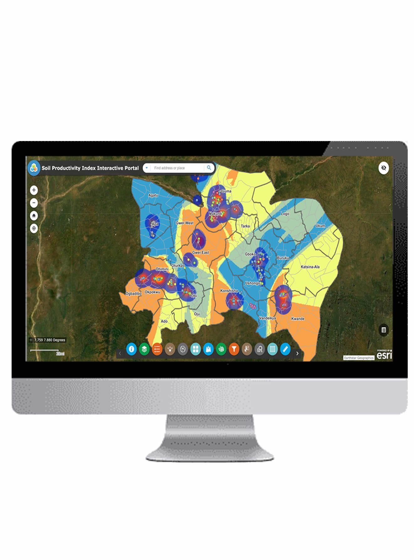
Upload data (farm boundaries) to Agroxchange crop monitoring platform
Farmer receives advisory from satellite via SMS in local language
Adewale Adegoke, Head of Agroxchange Technology Services and a strong advocate
Read More
of earth sciences in agriculture, has 17+ years of experience in the field of GIS and remote sensing implementation, with a focus on digital technologies for smallholder agriculture. His leadership acumen with proven skills in cross functional collaboration has led to the achievement of measurable goals in new business frontiers for Agroxchange, innovatively pioneering a smart farming advisory and technical centre in Nigeria. .
has over 12 years’ experience, developing and enhancing corporate strategies
Read More
for small business in North America and West Africa. As the co-founder and Director of Corporate Strategy in Agroxchange and Nigeria Flying Labs, he has successfully realigned the vision and strategy of the firm to meet changes in the business environment.
She is proficient in data science, precision agriculture, drone flights,
Read More
project management, spatial analysis, database management, GIS analysis, remote sensing using drone technology, satellite imagery, and aerial photography. She holds a first-degree certificate in Crop Production and Soil Science from Ladoke Akintola University of Technology in Ogbomosho, as well as a Project Management Certificate. She is experienced in smart farming technologies. She belongs to the International Society of Precision Agriculture (ISPA).
Olamiposi Caleb Fagunloye works at Agroxchange Technology Services and
Read More
Nigeria Flying Labs as a GIS Manager. At the Federal University of Technology Akure, he studied remote sensing and geographic information systems (GIS). He is a member of Data Science Nigeria, the Spatial Data Science Society of Nigeria (SDSSN), the International Society of Precision Agriculture (ISPA), the World Youth Alliance, and the moderation Subcommittee for OpenStreetMap's Local Chapters and Communities Working Group (LCCWG). He was also one of the Session Leaders for FOSS4G 2021, a conference on free and open-source software for geospatial applications. Caleb has expertise in remote sensing, automation, geographic information systems, and open source and he is also experienced in using satellite crop monitoring to optimise small holder agriculture and provide localised capacity building
Famusudo Oluwatomiwo holds a B.Sc in Agricultural Science from the Obafemi Awolowo
Read More
University(OAU). Oluwatomiwo is the Assistant Communications Manager at Agroxchange Technology Services and Nigerian Flying Labs where she leads the company’s communications team on implementing communications projects, strategic partnerships, administrative supports, social media strategies and tracking media exposure. Her skills include the following but not limited to Linkedin Advertising, Audience Targeting, Copywriting, Media Planning, Content Strategy, Business Development and Blogging.
Olabamide KAYODE-ADEDEJI is the Business Development
Read More
Manager for Agroxchange Ltd. A passionate farmer with over 20 years’ experience in Agricultural Production. His working experience cuts across banking, sales and of course Agriculture. Olabamide is very passionate about using Technology to enhance Agricultural Production.
He has a BSC in Sociology from the University of Ibadan. He has always been very keen on how I. T has the capacity to enhance business. He has been Certified by Microsoft as a Systems Engineer and Database Administrator since 2001.
Adeagbo Ayomide completed his Undergraduate education at the Adekunle Ajasin
Read More
University Akungba Akoko ondo state(2021) where he studied Microbiology , Ayomide is Fully licensed as a Drone Pilot under the US exception for limited recreational operations of unmanned Aircraft ( Title 49 of the United States code 49 U.S.C) Ayomide holds a Diploma in Robotics and A certificate in Digital Agriculture. He is currently also studying to acquire a certificate in Drone Mechanics. Also, while working at Flying Labs, he has gained proficiency in data science; web development; database management, and GIS analysis; Remote sensing using drone technology, satellite imagery, and Aerial Photography. He has gained experience working with ESRI software and he is also experienced in using satellite crop monitoring to optimise small holder agriculture and provide localised capacity building Ayomide is a member of African Drone Forum and in his free time, loves Researching about Drone technologies, Satellite imagery applications and how they can be used Both in Agriculture and to make life easier for humanity He is passionate about positive change through technology.
Agroxchange works with a network of over 300 field enumerators to profile and map farmers in Nigeria, with data output represented as agricultural field boundaries that serve as inputs into the Agroxchange crop monitoring platform.
The Agroxchange crop monitoring platform feeds multispectral satellite images that contain coded information and provide a visual measure of the variability in crop condition with reference to plant chlorophyll activity, nitrogen concentration and plant biomass over a period of time.
OVER
NDVI is a vegetable index, which is calculated according to the way a plant reflects and absorbs solar radiation at different wavelengths. The index allows from identification of problem areas of the field at different stages of plants growth from timely response. Pay attention to the areas where NDVI values differ considerably. For example, the areas of field that have an extremely low NDVI rate may indicate problems with pests or plants diseases; and the areas with an abnormally high NDVI signalize the occurrence of weeds.
NDRE is an indicator of photosynthetic activity of a vegetation cover used to estimate nitrogen concentrations in plant leaves in the middle and at the end of a season. It allows you to detect the oppressedand aging vegetation and is used to identiy plant diseases. It also makes it possible to optimize the timing of the harvest.
MSAVI is a vegetation index that allows you to determine the presence of vegetation in the eaely stages of emergence, when there is a lot of bare soil. The index minimizes the effect of bare soil on the display of vegetation maps. Based on the index, you can build maps for differential fertilizer application in the early stage of crop growth.
ReCI is an index of photosynthetic activity of a vegetative cover, sensitive to the content of chlorophyll in leaves. Since the level of chlorophyll is directly related to the level of nitrogen in the crop, the index allows you to identify the areas of the field that have yellowed or faded leaves, which may require additional fertilizer application
We are available for 24/7 for fitness
Initiation Stage
- Onboard would be farmer and exsiting farmer through our user needs assessment forms
- Identify and sign MOU with offtaker
Pre-farming stage
- Baseline mapping and data collection and primary production benchmarking
- Manage effective distribution and application of inputs
- Build capacity of farmers on Good Agronomy practices
- Create awareness and buying of farmers on harvest optimization
Farming Stage
- Record and report each growth stage of crop.
- Monitor production status from planting to harvesting using field teams and satellite crop monitoring platform to optimise harvest.
- Monitor compliance of farmers with Good Agronomy Practices with respect to harvest optmisation
Harvest Stage
- Work with aggregator to harvest and aggregate harvest
- Supply harvest to offtaker
Verification of inputs
Confirmation of harvest
Verification traceability of harvest
Insurance cover against crop loss
Death
Disability
Agricultural Business Risk Such As Outbreak Of Pest, And Disease, Flood, Fire, Animal Encroachment, Lightning


